BACKROADS BILL: Cycling through Cobalt’s mining legacy
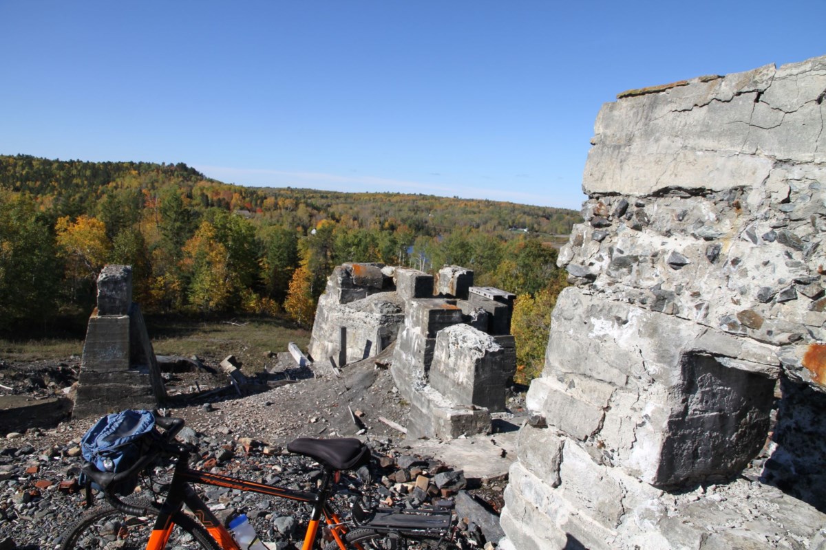
In the heart of Northern Ontario lies a town with a story etched into rock. Once a booming silver capital, today Cobalt is drawing attention for its rich heritage—and a new idea to explore it by bike There is a lot to see at the Nipissing Hill stop, especially the remains of past mining operations. 1 / 1 There is a lot to see at the Nipissing Hill stop, especially the remains of past mining operations. Advertisement Cobalt has been a target or source of a number of Back Roads Bill stories. Why? Through AI it said, “Back Roads Bill, through Village Media, often explores Cobalt and its history, particularly focusing on its artistic and environmental connections. He has documented the town's rich history, including the influence of artists who were drawn to Cobalt and its landscape, as well as the impact of mining on the environment.” Hmmm... AI knows everything, right? There was a literary review, could this be true? Most recently, there was the story of how artists once looked at the silver town through their creative eyes in Cobalt artists and the environment (check the archive of Back Roads Bill's work for Village Media at the bottom of this column). and a podcast on the same. In 2021, an engineering marvel par excellence was featured in Now and then: Evidence of an old idea with new applications. Then there was the story of Herbie the ghost in the downtown core featured in Visiting a ghost in Cobalt for a paranormal backroads experience. You do believe in ghosts? “Holy moly,” there is the famed Canadian poet, Henry Drummond, featured in The poetry of place in Cobalt piece. He wrote The Red Canoe in Cobalt. There is the story about the nearby Devil’s Rock, the most iconic vista in NE Ontario, which has mining adits. That one is called Devil's Rock: becoming less seldom seen, more iconic. The historic silver tour may be in jeopardy, as seen in the column, Last two headframes in Cobalt area threatened by deterioration, vandalism that was documented. In March 2021, the Ontario Northland Railway erected barriers at the Right of Way and Townsite Mine properties, citing a need for environmental and structural assessment. These remain unresolved and unchanged. What’s next, then, are thoughts of creating a cycling tour around one of the most historic towns in Canada. Background First, some history. On August 7, 1903, two railway contractors in search of lumber for railway ties discovered a substance that proved to be silver. Thousands of fortune seekers came up the Temiskaming and Northern Ontario Railway (ONR) to Cobalt: English and French Canadians, as well as countless then “new” Canadians from Europe. In 1905, 16 mines were active in the Cobalt area. By 1911, there were 34 mines producing 30 million ounces of silver. The population of Cobalt grew quickly from just 100 in 1903 to 10,000 in 1909. Cobalt was Ontario's first mining-boom town, and at its height was the world's fourth-largest producer of silver. In this period, land values rose to astronomical heights, thousands of claims were laid, and the town was hemmed in by mining operations. Initially, the mines were relatively small-scale and used simple technology, but soon major mining interests impacted the town geographically, politically and economically. The area, the town and portions of Coleman Township were designated a national historic site of Canada in 2002. The downtown commemorative plaque says, “…The history of this industry is written in the surrounding landscape. Open-cuts carved from the rock by hand reflect the earliest surface mining operations. Mining shafts, sunk as operations expanded, are marked by the presence of headframes. Concrete foundations, massive rock piles and remnants of tailings indicate the location of milling facilities for processing ore on site…” It is what remains that provides for an interesting bike ride (and by other modes) of various distances in and around the most historic of small towns. Why there’s a tour Maggie Wilson is the President of the Cobalt Historical Society and has been in the community since 2016. “Besides being a volunteer with the Cobalt, I am also on the board of the Haileybury Heritage Museum, and a founding member of a Northeastern Ontario Heritage-Patrimoine du nord-est de l'Ontario.” She is a rockhound as well. Upon first arriving in the community, she said, “My first impressions were less than complimentary. Tired-looking, shabby, deserted, desolate, barren... ‘ugly on the eye’ - a British colloquialism for ‘eyesore.’ So much so that any time my husband put forth the idea of moving north to retire, I resisted, big time.” “But we get to appreciate our surroundings,” Maggie said, “Once you live here for a while, once you meet the folks, and learn something about the history, once you have a chance to take in the astounding range of natural beauty, suffice to say, I love it here.” Her commitment to heritage appreciation is exemplary. “What speaks to me most is the back roads story. You look at those ugly gashes on the hillside and you feel admiration, respect, even a kind of love for the people who endured unimaginable hardship to make a living for their families.” This month, she explained the aforementioned headframe closures on the historic silver tour to her Cobalt Historical Society board of directors with an update. “Tourists can view both headframes from a safe distance, though the barriers are not effective at blocking access. Visitors can easily enter the sites, though we (Cobalt Historical Society), the guardians of the trail, are banned from doing so.” She explained, “In 2024, ONR maintained the sites, removing trash and trimming vegetation. The closure of the Right of Way site is particularly problematic in that we have raised $21,530 to repair the roof of the headframe. We must keep those funds in reserve, expecting the site to reopen at some point in the future.” In 2024 and into 2025, ONR conducted a Heritage Assessment of the two headframes to determine if they are worthy of the designation “historically significant.” Maggie said, “Kate Bondett, Senior Communications Manager, advises that ONR has completed the first phase of the Townsite and Right of Way Cobalt Headframe Structural Engineering Building Condition Assessment. ONR is currently awaiting final condition assessment reports from an engineering firm. The firm will complete a follow-up study and sampling work during Summer 2025 to investigate timber conditions and foundation of the structures.” Stay tuned. Maggie likes the idea of a cycling tour. Off the tour There’s more to see in Cobalt, and it is connected to its environmental legacy. Charles Dumaresq is the VP, Science and Environmental Management with the Mining Association of Canada (MAC). He is one one Canada’s foremost tailings experts. He leads MAC’s ongoing work on the development and continual improvement of requirements and guidance for tailings management which are being applied globally. By vocation and avocation, he sees Cobalt in a number of ways. Starting with graduate research on tailings in the area in the early 1990s. “I have gotten to know pretty much every tailings deposit in the area.” He said, “Tailings are kind of everywhere in Cobalt to be honest. Right on town behind the area and under the trailer park, in the lakes, on Nipissing Hill (Site 7 on the tour) on the east side of Cobalt Lake, Cart Lake, on the east side of Peterson Lake and of course Crosswise Lake.” “Cart Lake (Stop #5) is nice because the old Provincial Mine headframe is still standing at the south end of the lake. Cart Lake is also a simpler story to tell since the tailings all came from one mine (except some really old ones long since buried), and they didn't move them from somewhere else. There is an almost perfectly smooth rock outcrop just off the Ragged Chutes Road on the east side of Cart Lake that provides a place for 1-2 cars to park, and easy access down onto the tailings that are mostly now revegetated.” “Crosswise Lake (not on the tour - take Kerr Lk. Rd. to Cross Lk. Rd.) is a hodge podge of tailings that were put there (O’Brien Mine) and tailings that have migrated there from upstream areas closer to the town. They are also easily accessible. Nastier, though, from a contaminant’s perspective, compared to Cart Lake, since they are older. “The Crosswise Lake tailings are actually a lot younger than that. There were tailings deposited there from the earliest days of mining, but there were two active tailings lines discharging into the north end of the lake in the 1950’s and 1960’s, and that is the period when Cobalt Lake was also drained to recover and reprocess tailings, so there was a lot of downstream migration of tailings into the north end of Crosswise Lake and the creek that flows from the lake out to Lake Temiskaming in North Cobalt.” You can see a great deal of mining degradation at Crosswise Lake. It looks like a wasteland. From 1905-1937 there were five shafts with about 12 miles of drifts, cross-cuts, raises (connection upward) and winzes (connection downward). You see many of these terms within the Ontario Mineral Inventory of Abandoned Mines. Then there is an environmental success story to visit. “The only engineered wetland (1st St. in Cobalt) is the one built by the town to treat the municipal wastewater. It is built on tailings and is helping to reduce contaminant loads from the tailings, but that is not its primary objective - more an outcome of "friendly" biology since the reducing environment in the wetland also helps with arsenic which is the main contaminant of concern. It is not really accessible. The best place to view it from is the lower end of the Ste. Therese Roman Catholic cemetery north of town.” Charles said, “There is a lot that can be learned from Cobalt, as much as the stories there amount to everything you ever wanted to know about how NOT to run a mine but were afraid to ask. I have actually given a presentation with that title! Environment, social, indigenous, health and safety - so many things done there that were terrible. So far from the modern mining industry of today.” There is much to learn when touring around Cobalt. “One aspect of Cobalt that fascinates me in a scientific as opposed to a history/storytelling perspective of the degree to which nature has healed itself. I've been going there for 35 years now, and I have seen so many changes. “Apart from a couple of tailings deposits where there were some 'modest' reclamation efforts in the late 1990s, all of the recovery that we see there is natural. The marsh that has grown on the tailings north of Crosswise Lake is quite something and is helping to improve water quality. Even the once naked Nipissing Hill on the east side of Cobalt Lake is not nearly so naked anymore." There are other signs too. “Story Environmental in Haileybury has done a lot of work for Agnico Eagle and has done a good job of documenting things like improvements in water quality over time. There are some good news stories for sure.” He is a recently published author. “The history of the place fascinates me. So much so that I have written a book about HMCS Cobalt, as a Second World War convoy escort ship named after the town.” He also likes the cycling tour concept. Charlie’s context For a historic Cobalt context, before you visit, have a read of Cobalt: Cradle of the Demon Metals, Birth of a Mining Superpower by Charlie Angus. He has recently retired as the 21-year MP for Timmins-James Bay (now a new riding) and now front and centre with the Elbows Up Canadian patriotism campaign. But despite announcing his retirement from federal politics last summer, he has been more vocal than ever, speaking out against what he calls an "existential threat" to Canada from U.S. President Donald Trump's trade war and annexation threats through the Elbows Up patriotic campaign. But about the 2022 book, he has said, “I wrote this book for people who may not have any idea of where Cobalt is, or any connection to stories in Northern Ontario. “We have this tendency in Canada to treat our stories as local, but in my book, I argue that the story of Cobalt has implications for the history of all of the Americas. In that way, it’s a global story because mining and the movement of capital affect us globally.” His book is a tale of the early-twentieth-century mining rush and the events that happened here. He says, “It is the theft of Indigenous lands, the exploitation of a multicultural workforce, and the destruction of the natural environment, established a template for resource extraction that has been exported around the world. “The sudden flush of silver money from the mines of Cobalt hit sleepy Edwardian Canada like a high-octane jolt – strong enough to change the trajectory of development in both Ontario and Canada,” Angus says within. Charlie has lived in Cobalt since the 1990s I am thinking he may have biked around town. Bike, car and walk So, idle thoughts turned to creating an active cycling tour. As a bicyclist, how do you find the best lower-traffic roads and routes here in the north? When you Google: “cycling routes in northern Ontario,” you retrieve very little. Scroll down, eventually within the query results, there is an article on urban biking trails including North Bay, Sudbury, Timmins and then Manitoulin Island, but what about the hinterland? Cobalt’s Heritage Silver Trail was first organized in 1985 with the support of the Ontario Ministry of Northern Development and Mines. It has been expanded year by year since that time with the help of government and private funding, and many hours of volunteer service by members of the Cobalt Historical Society. Now it is three times its original size. In 2002, the Federal Government designated the Cobalt Camp as a National Historic Site of Canada. Here are two of my favourite stops on the existing tour that you can easily ride to. Stop #8, The Nipissing 81 Mine Site It sits on the flank of Nipissing Hill across Cobalt Lake from the town of Cobalt. Once covered with soil and trees, the hill was swept clean in 1914 by high-pressure hydraulic hoses in search of silver veins. It was how exploration was done, pressurized water was pumped from a plant on the shores of Cobalt Lake. The lack of vegetation on Nipissing Hill reflects this historic exploration practice, which would not be allowed now. Then pedal around to Stop #7 Nipissing Hill lookout It is built on the foundations of the Cobalt camp’s largest mill. Situated at the top of Nipissing Hill, the lookout provides a panoramic view of Cobalt and the surrounding area. So two good perspectives. Cemeteries tell a great deal about the heritage of a community. Silverland Cemetery is located on Cemetery Road on the west side of Highway 11-B/King St., ride out heading north, 2 km. Walk down the hill to read the compelling markers and note the unmarked metal and wooden crosses of many who lost their lives in the typhoid outbreak of 1909 and the Great Fire of 1922. It has a great view looking southwest towards town. Start with the Cobalt Historical Society website to see a lot of historic photos. For mapping information, go to The Cobalt Mining District National Historic Site of Canada Heritage Silver Trail for the interpretative booklet and map. Also, check the Back Roads Bill map of more sites. Move around in your own mode, there is much to learn and experience; it is not yet a designated cycling tour, but it could be. The roads have little traffic with a good mixture of pavement and hard pack, with a diversity of stops and distances; you choose the loops. The tour is one of the best examples of a well-signed, maintained and self-guided trail system in northern Ontario. Stuck in time. Cobalt yields a heritage treasure trove of buildings and scenes unlike anything else you're likely to drive, walk or pedal to and fro on the back roads.