An In-Depth Look at the Complexity of British English Dialects: A New Detailed Map
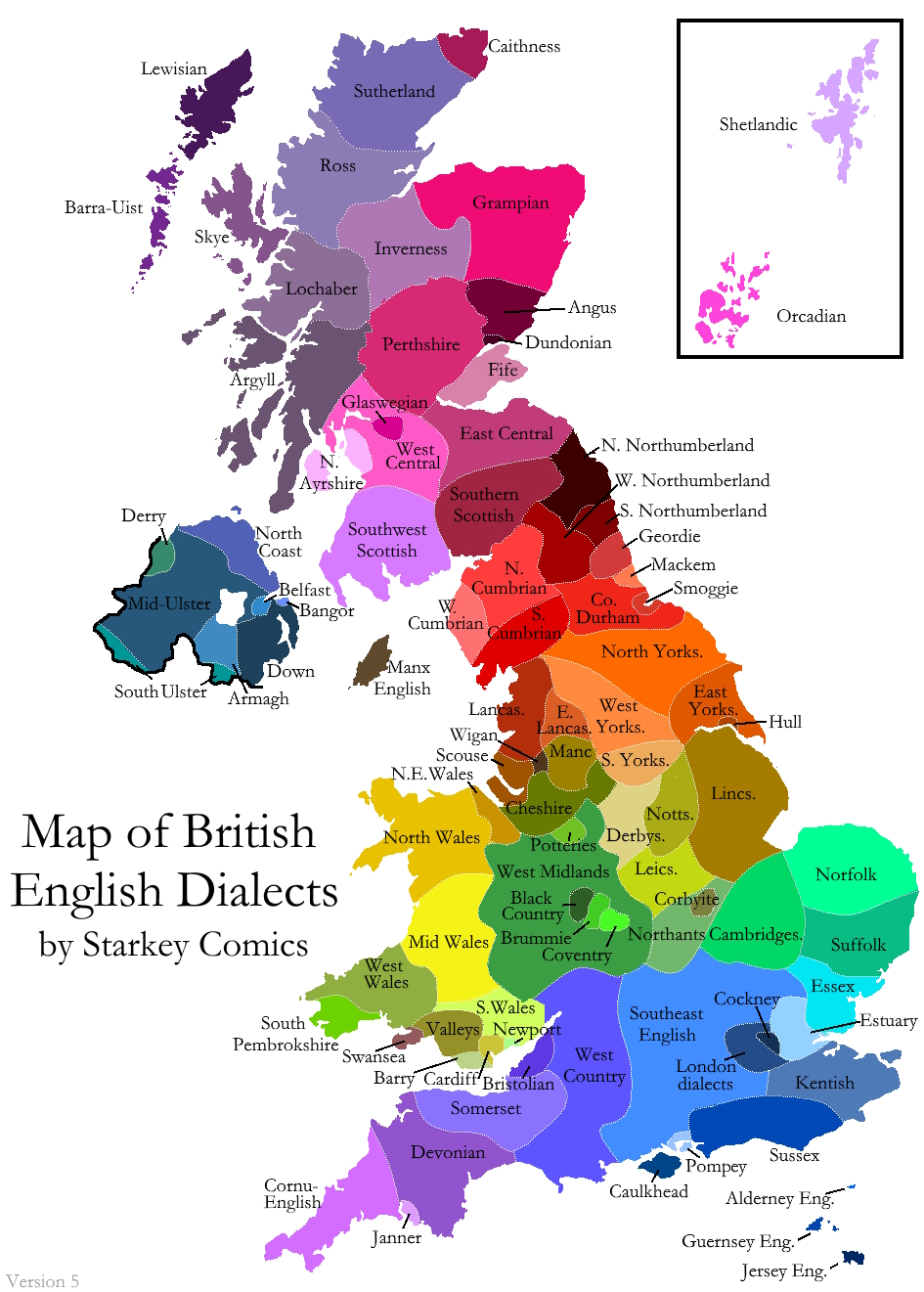
Creating this intricate map of British English dialects has been a labor of love, demanding extensive research and meticulous attention to detail. However, it will always remain incomplete and imperfect due to the inherent complexities of language itself.
Understanding the Depth of the Map
The richness of English dialects across the United Kingdom is astonishing. It is not unusual for individuals living on either side of a river, mountain, or even in neighboring towns to speak in markedly different ways. These variations, which often hinge on specific features, can instantly identify a persons regional origin to those attuned to such nuances.
This phenomenon is not unique to the UK; it is observed in numerous countries, including Germany, Norway, and France, where languages have evolved for centuries. Over time, geographic separation allows new linguistic traits to emerge and spread at varying speeds, resulting in distinct dialects. In some instances, these variations are subtle, only easily detected by locals, while in others, neighboring dialects can sound nearly like different languages to outsiders.
In my effort to illustrate this diversity, I have dedicated several years to gathering research from a multitude of studies, surveys, maps, and databases. I have also sought input from peers, particularly the members of my Facebook group, Ah yes, the British accent. Their feedback was invaluable in drawing more accurate dialect borders. The culmination of this work is what I believe to be the most comprehensive map of British dialects to date. However, it is vital to acknowledge that this map is still a work in progress and will likely never be fully complete.
The Limitations of the Map
Maps are powerful tools for visually conveying complex geographic data, yet they often oversimplify reality. One of the significant challenges I faced while creating this map is the lack of a precise definition for what constitutes a dialect.
While we can define a dialect as a variant of a language characterized by distinct vocabulary, pronunciations (or accents), and grammatical structures, determining when a variation is significant enough to be classified as a separate dialect is subjective. If we consider any noticeable difference in speech to signify a dialect, then my map adopts broad categories that may overlook finer details. For example, my quaint hometown, situated on the border between North Cumbrian and West Northumbrian dialects, possesses unique words and pronunciations that dont comfortably fit into either classification. However, depicting my town as an isolated bubble might set a precedent that complicates the overall representation.
In my dialogues with various individuals during the research process, many expressed a sense of distinctiveness about their village, town, or street when compared to surrounding areasoften with good reason. However, capturing such nuance would have made the map overly complicated and potentially inaccurate in other dimensions. I opted to delineate broader regions showcasing more apparent distinctions while also highlighting similarities between adjacent dialects through a carefully chosen color gradient.
Dialect Borders: Fluid and Complex
Dialect boundaries are rarely impenetrable lines. Instead, they often represent a gradient of variations that transition and merge over time, akin to colored inks diffusing into water. While there is a clear distinction between the dialects of Barrow in southern Cumbria and Carlisle in the north, the reality is that the region between them represents a spectrum of speech variations. Thus, the placement of dialect borders within Cumbria remains somewhat arbitrary, as dialects on either side frequently share more similarities with one another than with other areas of their respective counties.
Initially, I designed the first drafts of the map without distinct borders, opting instead for a blend of similar neighboring colors. However, this approach proved challenging for color-blind viewers. I then introduced dotted lines to indicate minor distinctions and solid lines for broader dialect groups. Nevertheless, this felt inadequate, particularly in the case of the Midlands, where there is no solid dividing line; rather, it represents a gradient between the East and West Midlands. I ultimately decided to retain only dotted lines, as a way of acknowledging the maps inability to truly convey the gradient's complexity.
In an ideal world, these colors would seamlessly blend and fade into one another, perhaps using intricate patterns and additional spatial dimensions, but that would compromise the map's clarity and comprehensibility.
Non-Regional Dialects
While many dialects are inherently regional, not all can be categorized strictly by geography. London serves as a prime example; my map simplifies this complexity by indicating London Dialects (plural). In reality, London is a melting pot of dialects, each deserving its own representation. However, due to the multifaceted nature of Londons dialects, attributes such as cultural and socioeconomic backgrounds play a much larger role than mere geography in shaping the way people speak.
Examples of dialects absent from this map due to their non-regional characteristics include Received Pronunciation, the standard dialect associated with prestige in southern Britain, and Pitmatic, which is spoken in scattered coal-mining towns throughout northeastern England.
Ultimately, while this map may feel unsatisfactory, arbitrary, and unfinished, it serves primarily as a testament to the remarkable diversity of English dialects found within the United Kingdom. It is also a medium through which I can share my admiration and fascination with this linguistic variety.
Clarifying the Term British
This map focuses specifically on British English dialects, which encompass the English language variations in the UK, including England, Scotland, Wales, and Northern Ireland, along with the Crown Dependencies (The Isle of Man, The Bailiwick of Jersey, and The Bailiwick of Guernsey). It does not extend to Ireland, as the Republic of Ireland is not part of the UK. While I considered expanding the project to include Ireland, the scale of the undertaking was already significant enough that adding this layer felt excessive.
Regarding the inclusion of Northern Ireland, it is a topic that may spark debate. The population of Northern Ireland is broadly divided into two groups: those who identify as Irish and those who consider themselves British. Given that some individuals in Northern Ireland identify as British, it seems appropriate to include them within the context of this map. This inclusion does not imply that every resident identifies as British; were I to create a map focused on Irish dialects, Northern Ireland would also feature prominently due to its substantial Irish-speaking demographic.
Moreover, there is a strong linguistic connection between Ulster dialects and those found in Scotland, both heavily influenced by Scots. Thus, Northern Ireland is a significant component in understanding the broader linguistic landscape.
For a deeper dive into the evolution of languages across Britain and Ireland, I invite you to explore my post entitled A Brief History of British and Irish Languages.
Regarding Scots/Doric Exclusions
This map exclusively depicts English dialects, meaning that Scots, including its variant Doric, is not represented. While Scots is closely related to English, it qualifies as a separate language. Notably, the English dialects in the Scottish Lowlands are significantly shaped by Scots, with many speakers being bilingual. However, there is no specific English dialect known as Doric. Similarly, dialects such as Welsh, Scottish Gaelic, Cornish, Manx, and Irish, while spoken within the UK, do not feature on this map. For an exhaustive list of the languages spoken across the UK and Ireland and their interrelations, please refer to my post, Every Native British and Irish Language.
As I continue to develop more maps, if you enjoyed this one, I highly recommend checking out Eight British and Irish Accent maps, which showcases the differences in pronunciation of specific sounds throughout Britain and Ireland.
If you appreciate content like this and wish to support my work, I would greatly value your contributions through my Patreon account. As an independent creator with a preference for avoiding advertisements, my patrons represent my primary source of income for my Starkey Comics projects. Their support enables me to dedicate substantial time and effort to producing these maps and images.
Lastly, I encourage you to follow my Facebook page, where I share updates on my creations, often before they appear on my website.